
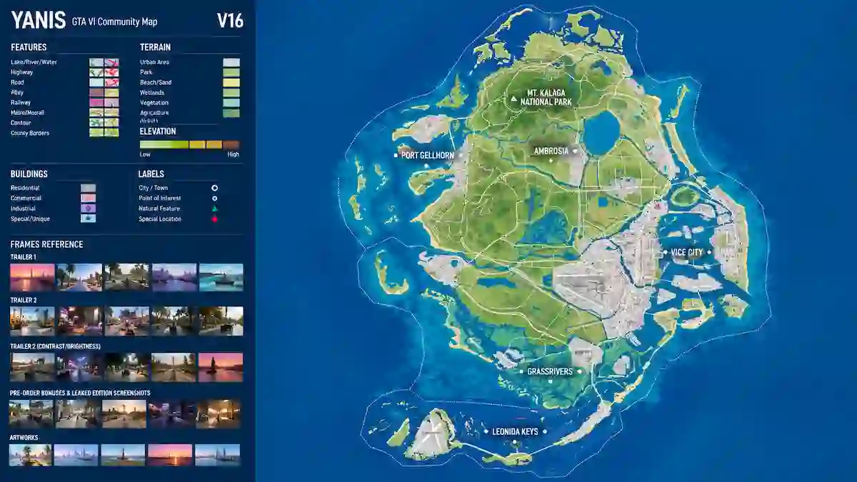
The GTA 6 map has received another major update from the community of fans who have been reconstructing Leonida from trailers, screenshots and other publicly available material.
The updated map is particularly interesting because the mapping community is no longer focused only on figuring out the overall shape of Leonida. The latest work is adding smaller roads, buildings, intersections and other details that are difficult to see on a zoomed-out map.
That makes the community project increasingly useful for understanding what Rockstar’s massive world could look like when GTA 6 launches.
However, there is an important distinction: this is not an official Rockstar map. It is a fan-made reconstruction based on available evidence, and some areas remain uncertain.
The Updated GTA 6 Map Is Getting More Detailed
The biggest change isn’t necessarily the overall outline.
Instead, the community is filling in the smaller pieces.
According to the latest discussion surrounding the updated map, the leaked or reconstructed overview mainly showed larger roads and buildings because of its zoom level. Community mappers are now working on the smaller roads and details that don’t appear clearly at that scale.
That matters because a map can look surprisingly empty when viewed from far away.
Once smaller streets, buildings and connecting roads are added, the same area can look much denser.
This is one reason the latest community map may give fans a better idea of how complicated Leonida could actually be.
Why the Mapping Community Is Still Working on It
Some fans questioned whether the mapping project still had a purpose after the circulation of a much more detailed map from a development build.
The community’s response has been fairly straightforward: the available map information does not necessarily show every small detail.
One discussion specifically pointed out that the larger map view leaves out smaller roads and buildings, giving the mapping community plenty of work to do.
In other words, the project has shifted.
Earlier efforts were largely about reconstructing the overall geography.
Now the focus is increasingly on accuracy and detail.
The Map Is Built From Multiple Pieces of Evidence
The GTA VI mapping community has been working on Leonida for years.
Earlier versions were created by connecting information from trailers, screenshots and other GTA 6 material. The community has repeatedly revised roads, locations and landmarks whenever new evidence became available.
One earlier version of the community map, for example, included changes to roads, rail lines, buildings, causeways and locations across areas such as Ambrosia and the Keys.
That history is important.
The current map isn’t the product of one person’s guess. It has developed through repeated revisions and contributions from a larger mapping community.
Rockstar Has Revealed Six Major Regions
While the community map is unofficial, Rockstar has provided plenty of official information about Leonida’s different regions.
Rockstar’s official GTA 6 material features:
- Vice City
- Leonida Keys
- Port Gellhorn
- Ambrosia
- Grassrivers
- Mount Kalaga National Park
Rockstar’s official media library contains dedicated screenshots for these regions, giving the community real reference points when reconstructing their approximate positions and environments.
The official website also highlights locations such as the Keys and Mount Kalaga, confirming that GTA 6 extends well beyond Vice City itself.
Vice City Remains the Centerpiece
Vice City is still the most recognizable part of the GTA 6 map.
The city is Rockstar’s modern interpretation of Miami and serves as the main urban environment.
But the updated community map makes it easier to appreciate that Vice City is only one part of a much broader world.
The surrounding regions provide different environments, roads and communities.
That variety is one of the most interesting aspects of Leonida.
Leonida Keys Add a Different Kind of Geography
The Leonida Keys are particularly important because they introduce a chain of coastal and island environments.
Rockstar has already shown several official images from the Keys, while the game’s story information places Jason in the region before his connection with Lucia becomes central to the story.
For the mapping community, the Keys are also challenging.
Roads, bridges, waterways and islands have to be positioned correctly, and relatively small errors can change the appearance of the entire area.
That’s why community map revisions continue whenever new visual evidence appears.
Grassrivers Could Be One of the Most Interesting Areas
Grassrivers represents another major change from GTA 5’s environment.
The region is inspired by Florida’s wetlands and gives Rockstar an opportunity to create an environment very different from central Vice City.
Official Rockstar screenshots already show Grassrivers as one of the major regions of Leonida.
From a mapping perspective, wetlands can be difficult to represent because there may be fewer traditional roads and more waterways, vegetation and open terrain.
That makes the smaller details particularly important.
Port Gellhorn and Ambrosia Expand the World
The community reconstruction also gives more attention to regions outside Vice City.
Port Gellhorn has a coastal identity, while Ambrosia has a more industrial and rural feel.
These areas help demonstrate why calling GTA 6 simply a “Vice City game” doesn’t fully describe the scale of the setting.
Rockstar has officially published separate imagery for both Port Gellhorn and Ambrosia.
The community’s job is to connect those confirmed pieces into a coherent representation of Leonida.
Mount Kalaga Gives the Map More Vertical Variety
Mount Kalaga National Park is another officially identified region.
Its inclusion is particularly interesting when comparing GTA 6 with GTA 5.
GTA 5 relied heavily on mountains and elevated terrain around Los Santos and Blaine County. GTA 6 appears to have its own northern mountainous area, giving players another reason to travel away from Vice City.
Rockstar has released multiple official Mount Kalaga images, confirming that the area is an important part of Leonida.
The Smaller Roads Could Change Everything
This may be the most important part of the latest mapping update.
A large-scale map can show the basic structure of a world, but smaller roads determine how players actually experience it.
Consider two maps with identical coastlines.
If one has only major highways, it will feel relatively empty.
If the other contains winding back roads, neighborhoods, industrial streets, rural paths and smaller connections, it will feel much more alive.
That’s why the community’s work on smaller roads is so valuable.
Is the Community Map 100% Accurate?
No.
It shouldn’t be treated that way.
Even fan projects that use extensive evidence still have areas where the exact position, shape or existence of a location is uncertain.
A community map can be extremely useful while still containing speculative elements.
One current fan mapping guide explicitly describes the reconstruction as a fan project and notes that Rockstar has not published the complete map.
That distinction is especially important when discussing specific roads or locations.
If something comes from Rockstar’s official screenshots, it can be described as confirmed.
If it comes from community reconstruction, it should be described as mapped, inferred or estimated.
The Map Could Continue Changing Before Launch
GTA 6 is scheduled to launch on November 19, 2026, so the community still has time to refine its reconstruction. Rockstar’s latest official material continues to provide new visual information, including the August 27 Extended Look.
Every new screenshot or official video can potentially answer another mapping question.
A building might reveal a street orientation.
A road in the background might connect two previously separated areas.
A mountain could help determine the position of an entire region.
This is why GTA 6 mapping has become an ongoing research project rather than a one-time fan activity.
GTA 6 Map vs the Old Community Versions
The evolution of the project is impressive.
Earlier versions had to rely much more heavily on speculation and triangulation.
As Rockstar released more trailers and screenshots, the community gained additional reference points.
For example, previous updates incorporated information from Trailer 2 and added or adjusted locations in the Keys, Watson Bay and other areas.
Later revisions continued to add roads, buildings, rail lines and environmental details.
The current version is therefore the result of years of incremental improvements.
What the Updated Map Tells Us About GTA 6
The biggest takeaway isn’t simply that the map is large.
It’s that Leonida appears to be designed around variety.
Players won’t just be driving between one city and another.
The world includes a major metropolitan area, islands, wetlands, industrial zones, coastal towns and mountainous territory.
Rockstar itself describes Leonida as a sprawling state and has repeatedly highlighted multiple regions in its official GTA 6 material.
The community map helps connect those official pieces into a larger picture.
What Remains Unknown
Despite all the work done by the mapping community, several questions remain unanswered.
Rockstar has not released a complete official map showing every road and location.
We also don’t have an official Rockstar measurement for the total playable area.
And even when a community reconstruction looks convincing, Rockstar could have changed parts of the world during development.
So the updated map should be viewed as a work in progress, not the final official blueprint.
Final Thoughts
The latest GTA 6 map update from the mapping community shows just how far fan research has come.
What started as an attempt to piece together Leonida from trailers and screenshots has evolved into a detailed reconstruction involving roads, buildings, regions and landmarks.
The newest work is especially interesting because the community is focusing on the small details that aren’t visible in a zoomed-out map. That could make the reconstruction much more useful for understanding how dense Leonida really is.
Rockstar has confirmed the major regions and continues to release official footage and screenshots, but the complete map remains unreleased officially.
For now, the community map is best treated as a detailed fan reconstruction, not an official Rockstar document.
But if the mapping community keeps refining it at this pace, fans may have an impressively detailed picture of Leonida ready before GTA 6 finally launches on November 19, 2026.
1 thought on “GTA 6 Map Update: Huge Details”